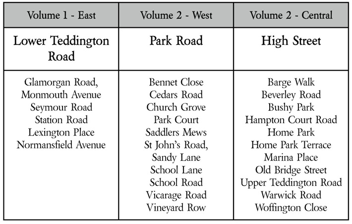
Lower Teddington Road

3 -

Aspen Close

Baygrove Mews

Glamorgan Road

Monmouth Avenue

Raeburn Close

Seymour Road

Station Road

Lexington Place

Normansfield Avenue

Introduction to the Project

HINT: click on an underlined Road name to view the list of properties

How to use this section of the site

Park Road

Bennet Close 
Cedars Road 
Church Grove 
Park Court 
Saddlers Mews 
St John’s Road 
Sandy Lane 
School Lane 
School Road 
Vicarage Road
Vineyard Rowhttp://www.parkroad.hamptonwickhistory.org.uk/ParkRoad/Park_Road/Bennet_Place.htmlhttp://www.cedarsroad.hamptonwickhistory.org.uk/Cedars_Road/Cedars_Road.htmlhttp://www.churchgrove.hamptonwickhistory.org.uk/ChurchGrove/Church_Grove/CHURCH_GROVE.htmlhttp://www.parkroad.hamptonwickhistory.org.uk/ParkRoad/Park_Road/Park_Court.htmlhttp://www.stjohnsroad.hamptonwickhistory.org.uk/St_Johns_Road/Saddlers_Mews.htmlhttp://www.stjohnsroad.hamptonwickhistory.org.uk/St_Johns_Road/ST_JOHNs_ROAD.htmlhttp://www.sandylane.hamptonwickhistory.org.uk/SandyLane/Sandy_Lane/Sandy_Lane.htmlhttp://www.schoolroadandlane.hamptonwickhistory.org.uk/School_Road_and_Lane/School_Road_and_Lane.htmlhttp://www.schoolroadandlane.hamptonwickhistory.org.uk/School_Road_and_Lane/School_Road_and_Lane.htmlhttp://www.vicarageroad.hamptonwickhistory.org.uk/Vicarage_Road/Vicarage_Road.htmlhttp://www.vicarageroad.hamptonwickhistory.org.uk/Vicarage_Road/Vineyard_Row.htmlhttp://www.parkroad.hamptonwickhistory.org.uk/ParkRoad/Park_Road/Park_Court.htmlshapeimage_2_link_0shapeimage_2_link_1shapeimage_2_link_2shapeimage_2_link_3shapeimage_2_link_4shapeimage_2_link_5shapeimage_2_link_6shapeimage_2_link_7shapeimage_2_link_8shapeimage_2_link_9shapeimage_2_link_10

Barge Walk

Beverley Road

Bushy Park

Elton Close

Hampton Court Road

Home Park

Home Park Terrace

Marina Place

Old Bridge Street

Upper Teddington Road

Warwick Road

Woffington Close

High Street